


The Brazilian presentation at the 10th International Architeture Exhibition poses the context for the exhibition Cities. Architecture and Society as an interpretation of São Paulo selected by the curatorial committee as one of the metropolises for discussion.
São Paulo developed on the basis of substantive responses to the urgent needs posed by a late but extremely rapid process of industrialization, so that providing the technical and material basis for manufacturing was one of the main logical principles guiding its development. This way of structuring of urban space may be seen in the location of its infrastructure and particularly its networks of road and rail routes.
Urban systems contain attributes capable of organizing the physical, spatial and functional interrelations of a significant part of the elements belonging to a metropolis. One idea to be investigated here is how interventions affecting the way these systems are used may work a viable strategy for tackling the transition from “industrial metropolis” to “contemporary metropolis.”
The relationship between the notions of territory, technique, programs and uses questions the limits of design actions. Numerous deliberate and concatenated initiatives affect the ongoing reconstruction of metropolitan space, even from a technocratic point of view, and the drive to exert a level of control that is not feasible, and never will be.
Among the initiatives to be redefined by the project are: understanding the systemic dynamics of the contemporary metropolis; interrelating networks and localities; identifying elements that lend stability to mobility; powering points of contact; articulating the diversity of programs and attributing use value to places. These initiatives are recognized as possible and desirable when it is realized that configuring the city as systemic project may be a viable response to the speed of transformation imposed by contemporaneity.
These and other collective debates conducted by a group of professionals invited by the Fundação Bienal de São Paulo led to an exhibition comprising a number of blocks examining the technical construction of territory and the creation of spaces. The aim is to approach the everyday dimension of life in the city by having built space valorized as home or residence.
Building the territory
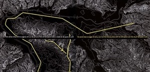
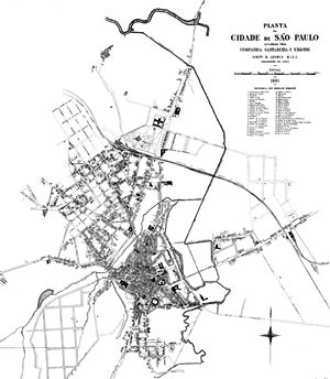
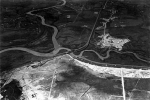
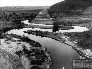
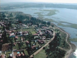
The city of São Paulo was founded in 1554 and emerged as a center for the Jesuit settlement strategically located on the banks of the Tietê River – which was an important means of conquering territories in the interior of the continent – and near a sea port just over the mountain range of Serra do Mar, situated on a plateau located approximately 700 meters above sea level. Not far from the source of the Tietê River, the city spread over the hills around watery valleys along the slow and winding course of the river, which has always been a decisive factor in the way the urban space was occupied here. The river basin comprises other important rivers and streams too, such as the Aricanduva and Tamanduateí. To the south is the Pinheiros River feeding the Billings and Guarapiranga reservoirs and ensuring the city’s water supply. Together they make up what is usually called the São Paulo Basin.
Made up of a succession of valleys and crests, Le Corbusier described its topography as an “ocean of hills” when he visited in 1929. His urban design proposal, drawn in the form of outline sketches on the occasion, identified precisely this characteristic and suggested constructing kilometers of “artificial land “ (mega-structures on which linear buildings would be placed alongside freeways) interconnecting the higher levels of the city to bring out its uneven topography. The boldness of this proposal, regardless of any assessment one might make of its feasibility or interest, is that it acts on the scale of the metropolis with an infrastructure design. This rationale is accompanied by poetic intelligence in relation to the importance of topography in configuring space, since the latter is not explicitly uneven or and a defining feature of the landscape, as it is in Rio de Janeiro, Caracas or La Paz, for instance, nor is it sufficiently tenuous and discreet to the point of not playing a key role in the process of occupying territory, as in New York or the main European capitals (with the significant exception of Lisbon).
In São Paulo, the difference in height between the riverside areas of the Tietê and the Avenida Paulista ridge, the highest plateau in the central area, is approximately 100 meters.
The development of urban occupation in São Paulo started with the high and salubrious sites before gradually settling down to the waterlogged riverside areas. These plains were not valuable from the commercial point of view, but became strategic for the city’s shipments and deliveries due to their transportation facilities. So traffic and water flows were combined right from the initial stages of the process of structuring the metropolis of São Paulo.
One possible interpretation of the development of São Paulo focuses on this territorial logic of support for industrial activities. In this scheme, the emphasis is on the interaction of three factors that made the São Paulo Basin riverside areas and fluvial plains strategic territory: the arrival of the railroad; the low price of the gently sloping land; and the abundance of water, which was the origin of industrialization in the city.
Chronologically, this process was headed by the successive introduction of railroads and the canalization of rivers and streams, both of which started in the second half of the 19th century; the structural road system with its riverside expressways from the 1950s to the 1980s; and by the approval of rules and regulations governing land use and occupation that directly affected the riverside areas from the 1970s to the present day.
The uninterrupted construction of infrastructure networks has led to far-reaching transformation of the site selected by the early settlers; the pattern modernized as new technologies became available , but the same forms of occupation of territory recurring. The effort to make originally unsuitable waterlogged areas suitable for habitation runs like a connecting thread through the history of the city. The construction of territory as a technical object to support industry was the result of an approach that stands out among conflicts in the characteristic urban design of São Paulo.
The city became an industrial metropolis in the 20th century and by the 1950s was Brazil’s financial capital and South America’s main business and trading center. The entire breadth and depth of its industrial network, including manufacturing, storage, distribution and marketing stages, depended on the efficacy of its support system.
The interpretation initially proposed here seeks to show the contradictory impacts of this territorial shaping on the different scales of the city. Although urban relations on the level of local experiences were frayed by these eminently technical initiatives, they also point to a potential for articulating peculiar to systemic initiatives.
This is, thus, a way of atributing an architectural gaze to these structures, usually driven by the technical pragmatism that in most cases eventually led to abandoned sites on the local scale of the city.
Given the scale of the metropolis, the concern for architectonic design must strategically intervene in the possible relations between the former and the localities, since the latter are the elements capable of operating significant reorganization for the whole. In what way are these systems and networked items of urban equipment actually used by the community?
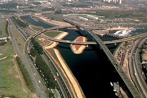
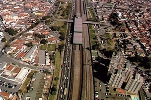
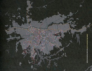
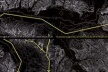
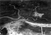
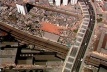
As museographic resource, the record of the forms of occupation of this territory – slow and discontinuous for four centuries, but accelerating vertiginously over the last fifty years – is captured by cartographic and photographic material, and by the inclusion of aerial views – all shown on film.
The bird’s-eye-view of the city incorporates the sensory experience of the metropolis in the register of the exhibition: sprawling, tentacle-like and multiform. However what is presented here is neither uncritical praise of the “polyphonic” concert determining the heterogeneous existence of the city, nor a direct critique of the perverse dynamics governing the profoundly unequal and excluding process of its spatial occupation.
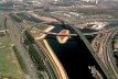
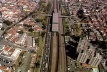
The aim is rather to ask viewers to penetrate the homogeneous infinitude of this urban fabric covering 2,139 square kilometers and holding approximatly 20 million inhabitants in what is referred to as “Great São Paulo”. Taking this sort of scale together with the number of commutes made in the metropolis (around 31 million every day, collective or individual transport, or on foot – approximately 10 million each means), one would suggest that there is an infinite variety of pathways, narratives and images of the city being constructed everyday; all intertwined and invariably associated with the mobility systems available in São Paulo.
With its significant degree of verticalization, built on the basis of legislation that establishes few singularities (such as distinctions in terms of plans, or lot occupation), the city seen from above presents a discontinuous and fragmented fabric that becomes recognizable only on the scale of the main civil engineering and infrastructure systems crossing its territory (nodes and axes for high-speed traffic). These “arteries” articulating the different sections of the metropolis often become “sores” on the local scale, helping to fray public spaces and degrade whole neighborhoods.
From this panoramic or bird’s-eye view, we can identify the axes of functional structuring of the metropolis. On this basis, the aim is to create conditions for an investigation of possible points of mediation between the different overlapping scales in the metropolis, with a swooping overview shifting the focus from the ways in which occupation of territory takes place towards ways in which space is appropriated.
1. Network and systems
São Paulo is constantly in motion. The city receives a significant volume of investment for the Brazilian context, although insufficient to meet all demand for housing, urban equipment and services. In the case of public investments, the key initiatives have been modernizing infrastructure networks, particularly in the transport and water resource sectors which have a major impact on urban structure.
Traffic routes and watercourses interacted on the basis of guidelines historically defined during the development of the metropolis, since the transport structure network followed the structure of São Paulo’s hydrographic basin.
Added mobility and the lack of water resources, as crucial issues to be tackled in the 21st century, have reinforced the close interconnections, and underline the strategic situation of the territory where the main technical systems are located. This situation becomes even more incisive when we learn that these systems relate directly to the industrial areas now being transformed.
Large-scale industrial restructuring has freed up extensive tracts of urban land in a phenomenon that is not new and may be seen in all the other industrial metropolises around the world. But in São Paulo, the task of rehabilitating these areas has yet to gain sufficient momentum for it to be described as a definite process.
Given the technical air that public debate and initiatives have taken on, it would seem opportune to redirect reflection to the issues of how to coordinate sectoral measures and aggregate a new programmatic agenda to boost the urban dimension of infrastructure networks, so that they act as agents for restructuring metropolitan living.
Inter-articulated “program-less networks” and “network programs “ enable us to identify certain points of contact between local interventions and the systemic vision needed to tackle the complexity of constantly changing demands.
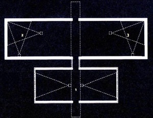
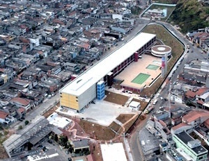
This module confronts a light on a rail vehicle running along urban rail tracks, with examples of equipment items functioning as networks that are outstanding for the complex fabric they establish on the territory. With marked presence on the scale of the metropolis, the following were selected for the excellence of their buildings or structures, and for the relevance of their programs: a cultural-leisure center sponsored by the organization Commerce Social Service (locally referred to by its acronym Sesc); a public school system doubling as a chain of community leisure and culture centers in needy neighborhoods – known as Unified Education Centers (local acronym CEUs); and trader organizations associated with the complex logistics of food provisioning in the city through street markets.
Unlike technical infrastructure items, they are project-based and spatially qualified initiatives, and characterized by diversity of programs, uses and users sharing the same items of equipment distributed in network form in the city in accordance with locational, accessibility and service logics, revealing the form of distribution of urban services over the territory. Although specific in terms of scale of intervention, they cater for demands on the metropolitan level; in some cases, they are simultaneously configured as centers of both local and metropolitan urban structuring.
Outrem
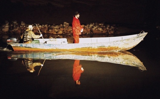
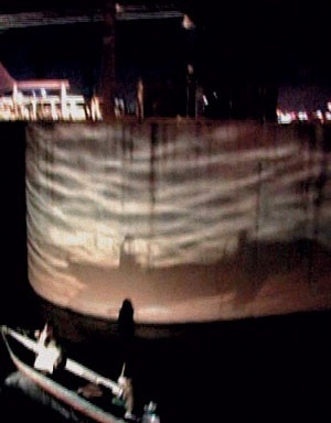
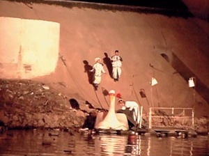
“Outrem”, executed for the “Rede de Tensão” exhibition commemorating the 50th anniversary of the Bienal de São Paulo in 2001, comprises an urban intervention conceived by Angelo Bucci, Milton Braga and Fernando de Mello Franco, and a multimedia installation by Joel Pizzini and Gianni Toyota.
The work extends beyond the representation of a project to become architecture in action itself, by transforming places. The issue posed was to cause the greatest possible repercussion on the scale of São Paulo, based on a specific artwork – a rehearsal for an intervention strategy in the metropolis.
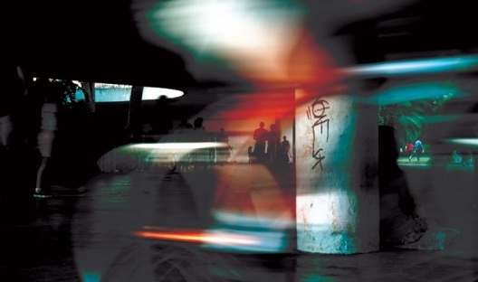
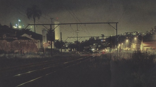
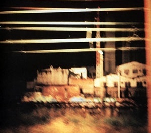
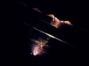
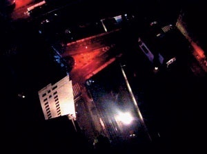
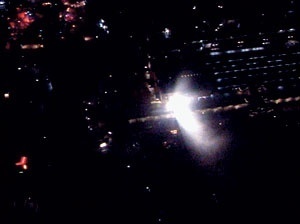
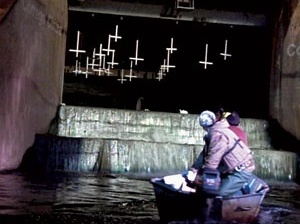
“Outrem” arose from a look at São Paulo’s extensive industrial and railway territory, on which a predictable transformation may be delineated. The urban intervention involved fitting light projectors to a maintenance convoy traveling along the line of a structure covering the entire metropolis. This moving light reveals a fundamental feature of São Paulo: its railroad system. By traveling the 270 km of urban railway network, we have a measuring instrument for its incommensurate urbanization.
The rail car sharply throws light on the spaces where its passes. On moving along, it operates as an agent of instantaneous and ephemeral transformation of the extensive and continuous industrial areas that characterize an industrial city in transformation, once again. It reveals the expectant state of a vast and promising territory, currently empty and awaiting new programs. When illuminated, it raises a prospective and imaginative gaze over the latter and causes concern for its own future and that of the contemporary metropolis.
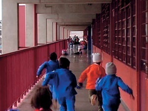
Unified Educacional Centers (CEU)
The Unified Education Centers – or CEUs – are part of the municipal school system. They are basically community centers organized around complexes of public equipment in which educational activities play the predominant role. These centers were based on previous experiences in the 1940s and 50s under the educator Anísio Teixeira. In the concept as initially proposed, these equipment items, or “park schools”, were located on large unoccupied sites and had a structural role in building community life in these areas.
In the current conception, the complexes combine several programs such as a school, a day care, a library, TV and study room, theater, sport and leisure areas. CEUs offer exclusive activities not found in other schools or sports centers in the outlying areas. So they operate as centers of equipment networks gravitating around each unit, and they lend them a metropolitan dimension.
Although controversial, the magnitude of their scale in contrast with the fragmented urban fabric around them provides physically and symbolically markers of the presence of the public power in the most underprivileged areas of the city. Thus they collaborate with urban structuring for their areas.
These multiple and diverse units are open to the community at all times, and not restricted to public school students, being open to the community on weekends. So there are overlapping programs and users, which decisively improves site management.
Once the bonds of belonging and community are strengthened, they also play an important role in the social structuring of peripheral neighborhoods in São Paulo.
Their design was conceived by the team at São Paulo’s municipal Buildings Department ( during the 2001/2004 city government), coordinated by architects Alexandre Delijaicov, André Takiya and Wanderley Ariza. This is not a frequent procedure in the context of public administration in São Paulo, since the public power has increasingly been restricted to management attributions.
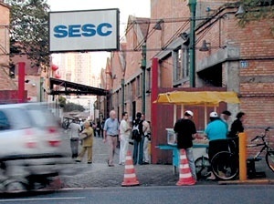
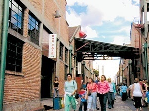
Sesc
The units belonging to the Commerce Social Service (local acronym SESC) are part of a large services network with centers all over the me tropolitan region. Each unit runs intensive cultural, educational and sports programs.
SESC units are certainly some of the most important promoters of cultural events in the city. They draw large numbers of people everyday – from different segments of the population – who use the library, visit exhibitions or see plays, or get involved in activities developed in studios, or simply go there for lunch in the canteen before going back to work.
It is the systemic rationale behind the SESC organization that in large measure explains its success. Units have consistent programs, and their structure is similar across the network, while not forgetting the specific circumstances in each location; they have good physical structure, meeting the needs of programs, and in some cases – as in the example selected for this exhibition – they are emblematic structures, too. Finally, the location of units in the metropolis is carefully based on the availability of public transport.
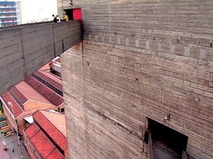
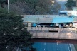
SESC – Pompéia was designed in the late 1970s by architect Lina Bo Bardi, and is perhaps the most outstanding example of the success of this type of program in the city of São Paulo. The center is on the site of an old barrel factory in the Pompéia neighborhood. The great beauty of this work lies in its sensibility in maintaining the layout and architecture of the factory buildings as a fundamental part of the design, while just introducing elements capable of transforming the place within its grandiose space, such as platforms for reading, bleachers, furnishings for the theater, ponds, a hearth, seats…
In counterpoint with the horizontal morphology of the factory buildings, Lina designed a vigorous structure for the sports center consisting of two concrete towers connected by catwalks. The “citadel”, as she called it, completes the group and marks the landscape of the neighborhood with a profound feeling of identity.
In addition to this beautiful architecture, another factor explaining the power of this project is the way it relates to the neighborhood. The block was redesigned and the whole center structured by an internal street stretching along one side, unchecked and opening through to the public thoroughfare; the other side leads to the large “deck-solarium”, a kind of “beach” joining the sports center to the other buildings. With all these characteristics, SESC Pompéia might be described as the materialization of an experience in which introducing a program and its architecture led to the creation of a place of great significance in the city of São Paulo.
Street markets
Street markets are a very special case among the so-called “network programs” distributed around the metropolis. They are systematically spread around the territory to meet local demands – if we consider the “unit” – or metropolitan demands, if we consider the network as a whole. They pose spatial and temporal relationships with the city that are totally distinct from the other examples.
The specific character of these markets means that they subvert the usual distribution scheme for commercial programs within the urban fabric. They occupy the public spaces of the city, its streets and squares (although only for a short time). Their architecture is light and ephemeral, a kind of “urban event” whose presence in the city depends on the weather.
We live in a period in which trade is increasingly more complex and sophisticated, in which both program and architecture strive to provide an exchange system working on very different scales. In this context, the traditional street market may be seen as a type of trade that is as old as the notion of the city itself – as a place for meeting and exchange.
Its continued presence in the contemporary metropolis is perhaps precisely due to this fluid character and its great ability to adapt, as a requirement for a period in which mobility has become a fundamental value.
2. Programs and uses
In everyday practice, the community constantly poses different ways of appropriating and reconfiguring spaces. A road is blocked off on weekends to become a leisure area, a running or cycling track, whether spontaneously or regulated by the public power.
In the sense of transgression, abseiling from urban viaducts, or even parcour, are activities that through their performances convert buildings into “urban nature” obstacles to be overcome. These are increasingly frequent situations in São Paulo and they often take place in some of the most inhospitable places in the city, and from them extract the pulsation of a lifestyle that is essentially urban. The play “BR3”, staged by the Teatro da Vertigem drama group takes this to the extreme by appropriating the abandoned riverside areas along the Tietê River and resignifying them.
It is not a matter of eulogizing the creative and irreverent ability of the community, in the light of repressed demands, to the detriment of the value of the project. The issue posed here is redefining the focus of the project and its strategies in relation to variables it cannot control – on the contrary, one wishes to potentiate them through its quality.
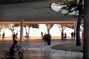
São Paulo offers projects seen as emblematic in relation to the richness of use of spaces. Public spaces in which “home” value is recognized, i.e. spaces whose indetermination means that they may be creatively appropriated by the community. The examples selected, once again, do not follow a single programmatic itinerary. They include an area covered by a marquee interconnecting five buildings in Parque Ibirapuera, designed by Oscar Niemeyer; the ramps on the building of the Faculty of Archtechture and Urbanism of the University of São Paulo (FAUUSP), designed by Vilanova Artigas; and the building of the São Paulo Cultural Center designed by Eurico Prado Lopes and Luiz Telles.
In all three cases, a key point is that their predominant function as thoroughfares is associated with other unnamed functions associated with spending time there or meeting people, i.e. the enjoyment of intrinsically porous, open and non-segregated spatiality. What we see in these cases is not creative appropriation of spaces by the community, which subverts situations of spatial constriction that are very common in the city. On the contrary, what we have in these examples is an initiative that potentiates the project’s openness, since it somehow fills the vectors of indetermination left by the architect with the aim of supporting the unpredictability of life. This approach, rather than being an architectural design guideline for building artifacts, is a design-based position in relation to the issues posed by contemporaneity.
BR3 *
The play “BR-3”, performed by the drama group Teatro da Vertigem and directed by Antônio Araújo, has implications that reach far beyond the city’s theatrical scene. By taking the Tietê River as the stage for the performance, the play provides new signification for this landscape, shedding light on its quality as “place” and – on a broader register – on the history of the constitution of São Paulo.
The Tietê and its riverside areas are throughfares, with temporary occupations whose abandonment wipes away any bond with history or human communities. Therefore by submerging in this landscape, the play provides an experience of radical deterritorialization. On the other hand, by breaking down the barrier of disgust that viscerally separates people from this abject “non-place”, by sailing on it, one penetrates the thickness of its tangible dimension. The aim is not direct critique of the mechanical and functional dimension created by these spaces, but rather the blunting of experience that goes with it.
Sailing on the Tietê River means mentally recreating the archeology of a city that grew by occupying the riverside areas with expressways for automobile and rail traffic, making them important structural axes of the metropolis, but at the same spaces without any human quality.
The play in no way seeks some hidden poetry of the Tietê River. It does seek to alert us to be open to the cognitive reterritorialization that experiences of this kind can afford: seeing São Paulo through the eyes of the mind.
* Based in WISNIK, Guilherme. “Rio e marginal Tietê, terra de quem?”. In Folha de São Paulo, 24 abr. 2006.
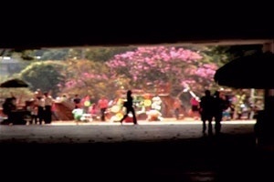
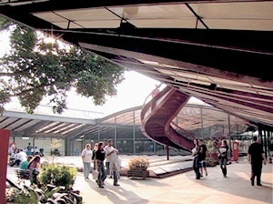
Marquee of Ibirapuera Park
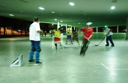
The covered area known as the marquee of Ibirapuera Park is part of an architectural group designed by Oscar Niemeyer on the occasion of the 4th centennial of the founding of the city of São Paulo in 1954. It provides a connecting route between five main buildings: a large auditorium, recently inaugurated to complete the original project, and four exhibition pavilions. These pavilions currently house some of the city’s leading museums, including the Museum of Contemporary Art of the University of São Paulo, the Afro-Brazilian Museum, and the Fundação Bienal de São Paulo.
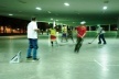
The Marquise covers a large flat area of reinforced concrete measuring approximately 26,000 m2 with a length of 650 m, and a huge empty space is configured under the roof. Its excessive generosity means that it transcends far beyond the strict function of a covered pedestrian connection so it hosts an enormous variety of events and unexpected uses. Skateboarders, jugglers, shows, skaters, fairs or markets, strollers, and hockey games share the same place.
Its situation as a freely available space, without any a priori signification, defined programs or function, located between the pavilions and forming part of the group but with its own autonomy, means that the structure does not determine human action, but on the contrary provides for multiple social appropriation of space. The implications of this freedom can only be described a posteriori: in this sense the project is sheer potentiality.
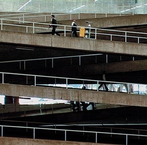
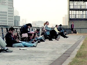
FAUUSP
The Faculty of Architecture and Urbanism building of the University of São Paulo (FAUUSP), was designed by architect Vilanova Artigas and inaugurated in 1961; its spatial solution is closely identified with the production of the “São Paulo school” of architecture. An outstanding central patio articulates all the sections functionally composing the building under a common covering.
In the case of FAU, the “Caramelo” hall, as it is known, establishes an uninterrupted relationship with the exterior without the mediation of gates or fences. It acquires the ambivalence of an enclosure inside the building, but is openly available for collective use. “Caramelo” is the space par excellence for sporadic events at the school. Numerous historical images suggest the student demonstrations, exhibitions, and festivities etc that take place in the hall on an occasional basis.
At one of its ends is the building’s ramp system. Strategically located and generously widened, it transcends its function as artifact for traffic to be configured as the primary place for habitual meetings at the school.
From the ramps there is a privileged view of all the units organized around the emptiness of “Caramelo.” Seen from the hall, through the built perspective, the ramps act as focus. Rather than emptiness, it is now these everyday events that acquire the protagonism of the gaze.
São Paulo Cultural Center
São Paulo Cultural Center (Centro Cultural São Paulo, CCSP) is located on the sloped valley of the Itororó and on the city’s main north/south expressway. In an exemplary occupation, the building reconstitutes the green slope characterizing the valley and gives a sense of continuity to the relief.
The structure is hardly apprehensible as an object and is shown in formal terms in the huge sweeps of its roof, with its length making it approach the horizontal plane of the ground. It is this resource – the scale of the structure, its domestic and unusual height, combined with the generous openings of a structure that has no doors – that invites people passing by to come in, as an extension of the public walkway.
In the interior, there is the surprise of covered and uncovered patios, such as a 700 m2 garden conserving the site’s original vegetation.
The structure acts as if it were a large square, communicating and organizing specific programs installed there: exhibitions, workshops, auditoriums, disk collection, and a library covering more than 9,000 m2.
Few other buildings in São Paulo have succeeded in creating such a high level of identity with the public. Beyond its function as cultural complex, the quality of its spaces allows this equipment to become a space for resting or meeting other people on its patios, high gardens and balconies. It is this characteristic that impels and valorizes the activities held at the institution. Located near the Vergueiro subway station, its annual visitation number is about 650,000.
São Paulo Cultural Center, covering over 50,000 m2, was initially designed as a municipal library by architects Eurico Prado Lopes and Luiz Benedito Telles. After significant program changes, and many incidents involving the structure, it was inaugurated in 1982.
note
NE
Exhibition “Networks and places”, brazilian participation in the 10ª Mostra Internazionale di Architettura, Bienalle di Venezia, 2006.
credits
Comissão curatorial / Curatorial committee
Jacopo Crivelli Visconti
Coordenador / Coordinator
Fernanda Barbara, Fernando de Mello Franco, Guilherme Wisnik, Juan Pablo Rosenberg, Marcelo Morettin, Marta Bogéa, Martin Corullon
Participaram da fase de debates / Took part in the debates
Fabio Valentim, Fernando Viegas, Luciana de Carvalho Pinto, Raul Juste Lores, Vinicius Andrade
Coordenação dos textos / Texts coordination
Fernando de Mello Franco
Coordenação dos desenhos / Drawings coordination
Martin Corullon
Produção / Production
Fundação Bienal de São Paulo, Liliane Fratto
Projeto gráfico catálogo e painéis / Graphic design
Mayumi Okuyama
Desenhos / Drawings
Anna Ferrari, Luciana Mota, Léonie Zelger
Coordenação Editorial / Editorial coordination
Ana Gonçalves Magalhães, Ana Elisa de Carvalho Silva
Tradução / Translation
Thomas Nerney
Pré-impressão / Pre-print
Photostop
Impressão / Printing
Patrocínio / sponsorship da Imprensa Oficial do Estado de São Paulo
Vídeos / Videos
SESC, CEU, Marquise do Parque Ibirapuera, FAUUSP, Centro Cultural São Paulo, feiras livres e vistas aéreas
Direção e montagem / Direction and montage
Otávio Cury / Mutante Filmes
Produção / Production
Ana Mendonça, Everton Taccini, Jorge Tsunoda, Marcelle Governatori
Ano / Year
2006
“BR-3”
Direção do vídeo / Video direction
Evaldo Mokarzel
Montagem / Montage
Marcelo Moraes
Produção / Production
Casa Azul
Direção de produção / Production direction
Afonso Coaracy & Paula Knudsen
Fotografia e câmera / Photography and camera
Thiago Ribeiro, Kiko Costato, Fernando Adedd, Pedro Volpi Eliezer, Rodolfo Figueiredo, Cristian Saghaard, Carlos Rodrigues Botosso, Jéferson Peixoto & Vicente Cárdia de Almeida Prado
Ano / Year
2006
“Outrem” Intervenção urbana / Urban intervention
Concepção e projeto / Realization and Project
Angelo Bucci, Fernando de Mello Franco & Milton Braga
Luminotécnica / Light design
Guilherme Bonfanti
Videoinstalação / Videoinstallation
Direção geral / General direction
Joel Pizzini
Direção de arte / Art direction
Gianni Toyota
Produção / Production
J.S. Lopes
Trilha sonora / Sound track
Michelle Agnes & Nelson Pinton Filho
Ano / Year
2001
Projetos / Projects
Serviço Social do Comércio – SESC Fábrica da Pompéia / Commerce Social Service – SESC Pompéia factory
Lina Bo Bardi
Colaboradores / Collaborators
André Vainer e Marcelo Carvalho Ferraz
Local e data / Place and date
São Paulo, 1977-1982
Centro Educacional Unificado CEU / Unified Education Center
Alexandre Delijaicov, André Takiya, Wanderley Ariza
Local e data / Place and date
São Paulo, 2002-2003
Marquise do Parque Ibirapuera / Marquee of Ibirapuera Park
Oscar Niemeyer, Zenon Lotufo, Helio Uchoa e Eduardo Kneese de Mello
Local e data / Place and date
São Paulo, 1951-1955
Faculdade de Arquitetura e Urbanismo da Universidade de São Paulo – FAUUSP / Faculty of Architecture and Urbanism of the University of São Paulo
João Batista Vilanova Artigas e Carlos Cascaldi
Local e data / Place and date
São Paulo, 1961
Centro Cultural São Paulo / São Paulo Cultural Center
Eurico Prado Lopes e Luiz Benedito de Castro Telles
Local e data / Place and date
São Paulo, 1977-1982
Agradecimentos / Acknowledgments
Alexandre Delijaicov, André Takiya, André Vainer, Antônio Araújo, Bebete Viégas, David Rego Jr., Evaldo Mocarzel, Florencia Ferrari, Guilherme Bonfanti, Joel Pizzini, José Oswaldo Vilela, Kátia Kuwabara, Marcelo Carvalho Ferraz, Nelson Kenji Kobayashi, Nelson Kon, Otávio Cury, Regina Meyer, Roberto Áudio, Rogério Canella, Walter Gentil, Wanderley Ariza
about author
Curatorial committee: architects Jacopo Crivelli Visconti (coordinator), Fernanda Bárbara, Fernando de Mello Franco, Guilherme Wisnik, Juan Pablo Rosenberg, Marcelo Morettin, Marta Bogéa e Martin Corullon.